
On October 7th last year, the Israeli occupation army announced the launch of Operation Iron Swords in response to the Al-Aqsa Deluge operation carried out by the Al-Qassam Brigades, the military wing of Hamas movement.
The next day, at exactly 12:55 am, some residents of the Gaza Strip received warnings from the Israeli army to head towards points identified as safe zones.
At that time, the Khalaf family was forced to flee from the eastern area of Al-Shojaeya neighborhood, located north of the Gaza Strip, to the Al-Ma’mounia school belonging to UNRWA, fleeing the shelling that targeted the vicinity of their home, as Tareq Khalaf, one of the displaced persons to the school, informed us.
Hours after their displacement – around 1:00 am on October 8th – Israeli airstrikes targeted the schoolyard, located in the Al-Rimal neighborhood, which was sheltering hundreds of displaced persons, leading to injuries among them according to UNRWA, despite the school being in one of the areas designated by the Israeli army as safe zones.
Al-Ma’mounia School is one of dozens of sites targeted by the Israeli army’s airstrikes in areas previously designated as safe, in the northern, central, and southern regions of the Gaza Strip. This was documented by tracking the Israeli airstrikes that occurred on the same day the army issued evacuation guidelines.
We worked on documenting the geographical location of several buildings targeted by the Israeli airstrikes, despite being within the safe zones. Additionally, we observed that Israeli shelling targeted residential buildings inhabited by civilians without prior warning.
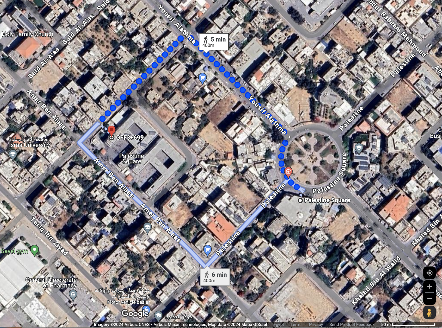
In his conversation with us, Tareq explained that the family headed towards the vicinity of Al-Ma’mounia School after learning from some residents of Al-Rimal neighborhood that the Israeli army had requested them via phone calls to head towards the area of Palestine Mosque. This led civilians to seek refuge in the school, which is located two minutes away by car/5 minutes on foot from the mosque.
Despite following the Israeli army’s guidelines, which were also issued in the form of maps published on the spokesperson for the army Avichay Adraee’s Facebook page, the displaced individuals were surprised by intense shelling around the school, followed by a direct bombardment of the schoolyard with dozens of missiles.
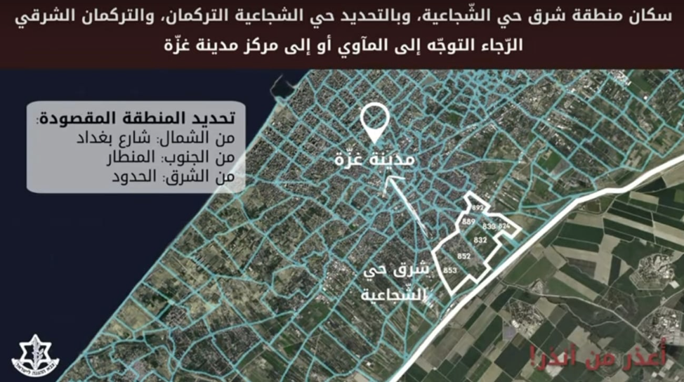
One of the maps published by the spokesperson for the Israeli army on October 8, 2023, calls on residents of the eastern part of Al-Shojaeya neighborhood to evacuate to Gaza City. Source: Israeli Army Spokesperson Avichay Adraee’s Facebook page.
Several displaced individuals, including some members of Tareq’s family, were injured to varying degrees as a result of the Israeli bombardment of the schoolyard. Among them was his sister, who sustained a fracture in her ankle joint, prompting them to evacuate once again to Al-Shifa Hospital.
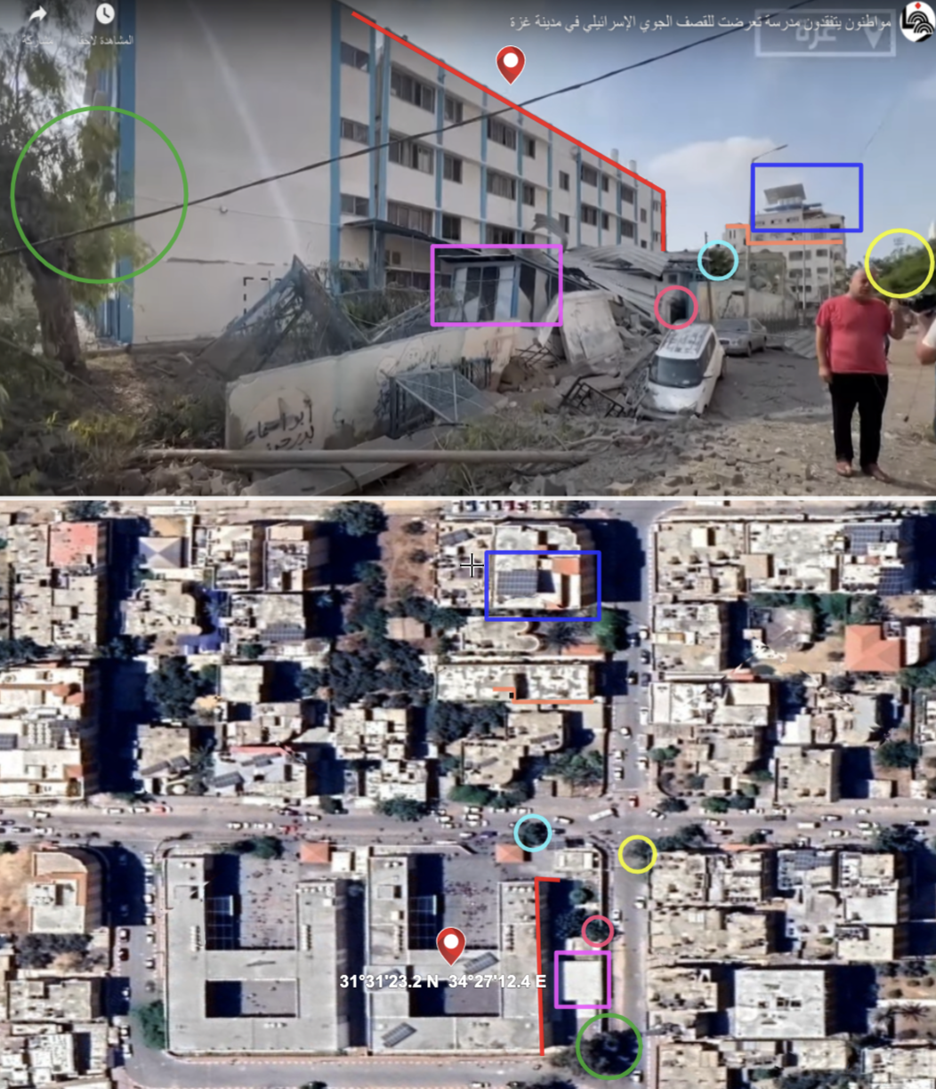 The marked signs indicate a geographical match of the buildings and surrounding trees near the location of Al-Ma’mounia School in Al-Rimal neighborhood, Gaza. Source: Screenshot taken from a video by the Palestinian News Agency (WAFA) showing the aftermath of the Israeli shelling of Al-Ma’mounia School, and an image of the school using satellite imagery (Google Earth).
The Palestinian News Agency (WAFA) released a video on October 8, 2023, via YouTube, showing the aftermath of the Israeli bombardment of the vicinity and courtyard of Al-Ma’mounia School. We verified it through the reverse search process (1) using various search engines.
We were able to pinpoint the geographical location of the school, which is situated near Palestine Square in Al-Rimal neighborhood, with coordinates: (31°31’23.2″N, 34°27’12.4″E), through a geographical matching process between a screenshot from the video clip illustrating the effects of the bombardment on one side of the school and another image of the school from satellite imagery (Google Earth).
![]()
Gaza City Center (October 8, 2023)
A compilation of four maps released by the Israeli army spokesperson Avichay Adraee via Facebook on October 8, 2023, all directing towards the necessity of heading to the “Gaza City Center,” but it was targeted.
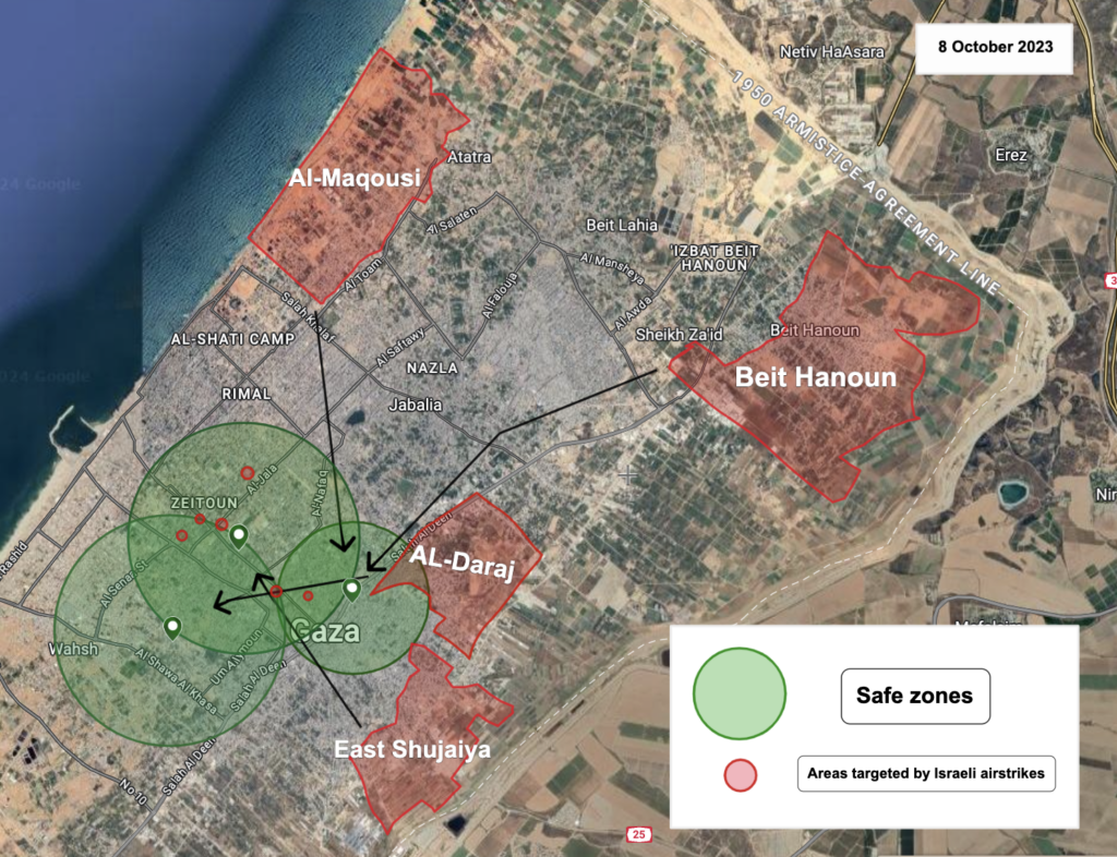
The warnings issued by the Israeli army on October 8, 2023, covered areas: (Al-Maqousi, Beit Hanoun, east of Al-Shojaeya neighborhood, Al-Daraj neighborhood), through a series of videos published on the Facebook page of the Israeli army spokesperson Avichay Adraee.
We tracked the points designated by the Israeli army as safe zones and compiled them into one map after matching the four maps, all of which directed towards heading to what was referred to as the “Gaza City Center” without specifying specific neighborhoods or areas.
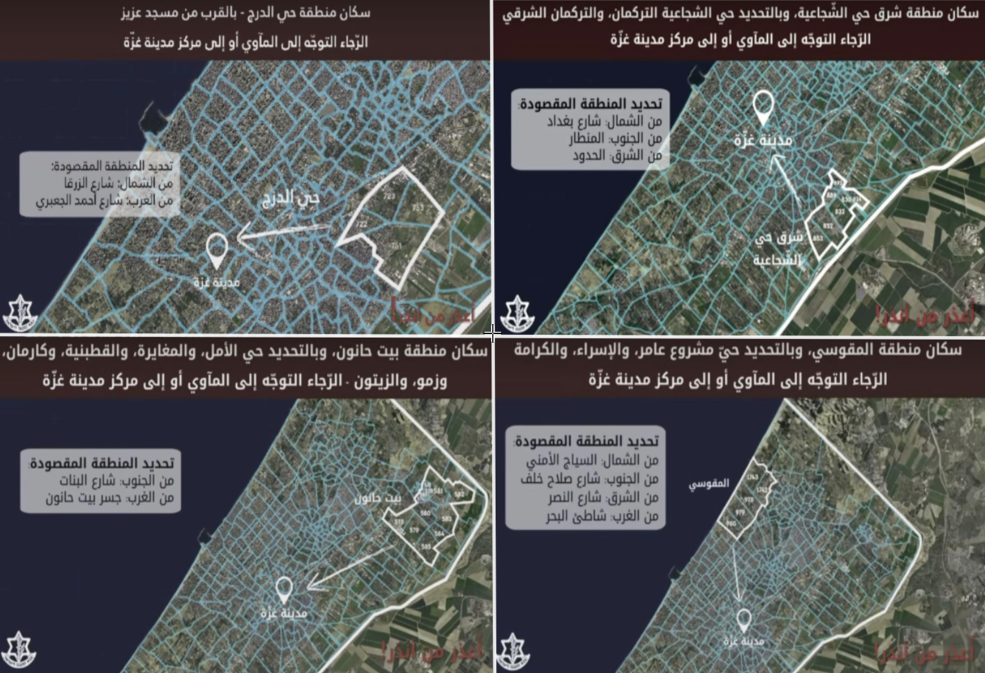
Four maps published by the Israeli army spokesperson on October 8, 2023, call on residents of (eastern Al-Shojaeya neighborhood, Al-Daraj neighborhood, Al-Maqousi, Beit Hanoun) to evacuate to what was termed Gaza City Center. Source: Israeli Army Spokesperson Avichay Adraee’s Facebook page.
By redrawing the maps on Google Earth, we observed that the points specified in the four maps indicate three adjacent areas. By matching a map of Gaza City Municipality with these points, we found that the designated safe zones included the neighborhoods of Al-Rimal, Al-Zaytoun, Gaza City, Al-Tuffah, and Al-Sabra.
We noticed that one of the points designated as “safe” by the Israeli maps, directing Beit Hanoun residents towards it, partially overlapped with the boundaries of the Al-Daraj neighborhood, which the army warned was a target for Israeli airstrikes.
Tracking the Israeli airstrikes on the Gaza Strip through data from the Palestinian Center for Human Rights and several local Palestinian media outlets, we were able to identify 6 targets struck on October 8, despite being within the “safe zones” designated by the Israeli army in the statement released earlier that day.
The targets we managed to identify included: Watan Building, Al-Aqsa Building, Abu Sido Building, Al-Ma’mounia Preparatory School belonging to UNRWA, the vicinity of Gaza City Municipality, and the Islamic National Bank.
We documented 5 targets through the process of geographical matching between images of the sites bombed by the Israeli aircraft and satellite imagery on Google Earth, including Al-Ma’mounia School, which we documented at the beginning of the investigation.
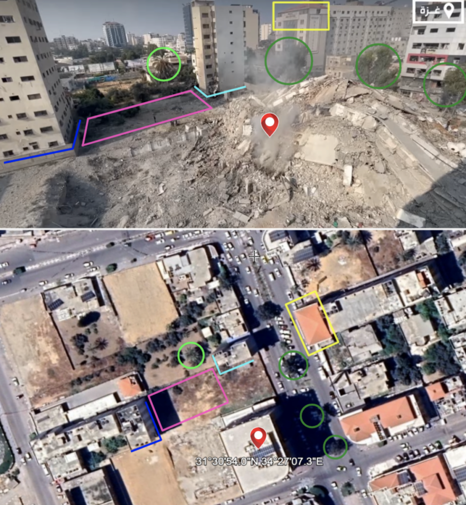
Comparing the screenshot taken from a video published by the WAFA agency on October 8, 2023, with the satellite image from Google Earth, the marked signs indicate a geographical match for the location of the Watan Tower. Sources: WAFA agency, Google Earth.
The Palestinian News Agency (WAFA) released a video on October 8, 2023, documenting the aftermath of the destruction that befell the Watan Tower located on Jalaa Street in Al-Rimal neighborhood, Gaza City, in the northern part of the Gaza Strip.
We verified the video through a reverse search process across various search engines and through the geographical matching process between a screenshot taken from the video and another image of the area via satellite imagery (Google Earth). Through this, we were able to determine the coordinates of the Watan Tower: (31°30’54.0″N, 34°27’07.3″E).
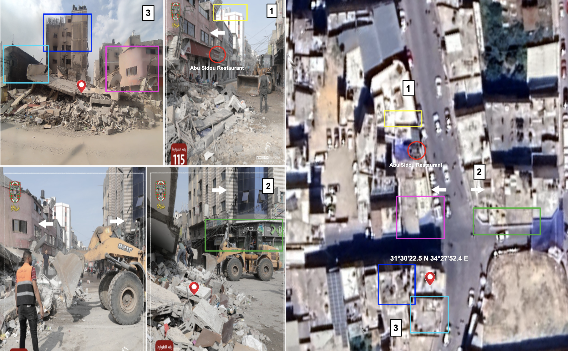
The images (1), (2), and (3) show the geographical landmarks of the buildings located on Unity Street on both sides (right and left), which correspond to the geographical landmarks in the satellite image (Google Earth) of the area where Abu Sido Building is situated. Sources: Images (1) and (2) from Gaza Municipality via Facebook, Image (3) from a Facebook user, Image (Google Earth).
We have observed images illustrating the aftermath of the destruction that befell Abu Sido Building, which Gaza Municipality posted on its Facebook page on October 8, 2023.
We noticed a restaurant sign bearing the name “Abu Sido” in the same row as the damaged building, and opposite to it is a mobile shop (Jawal). Through geographical search on Google Earth, we were able to determine the coordinates of Abu Sido Building: (31°30’22.5″N, 34°27’52.4″E), located on Unity Street in Gaza City.
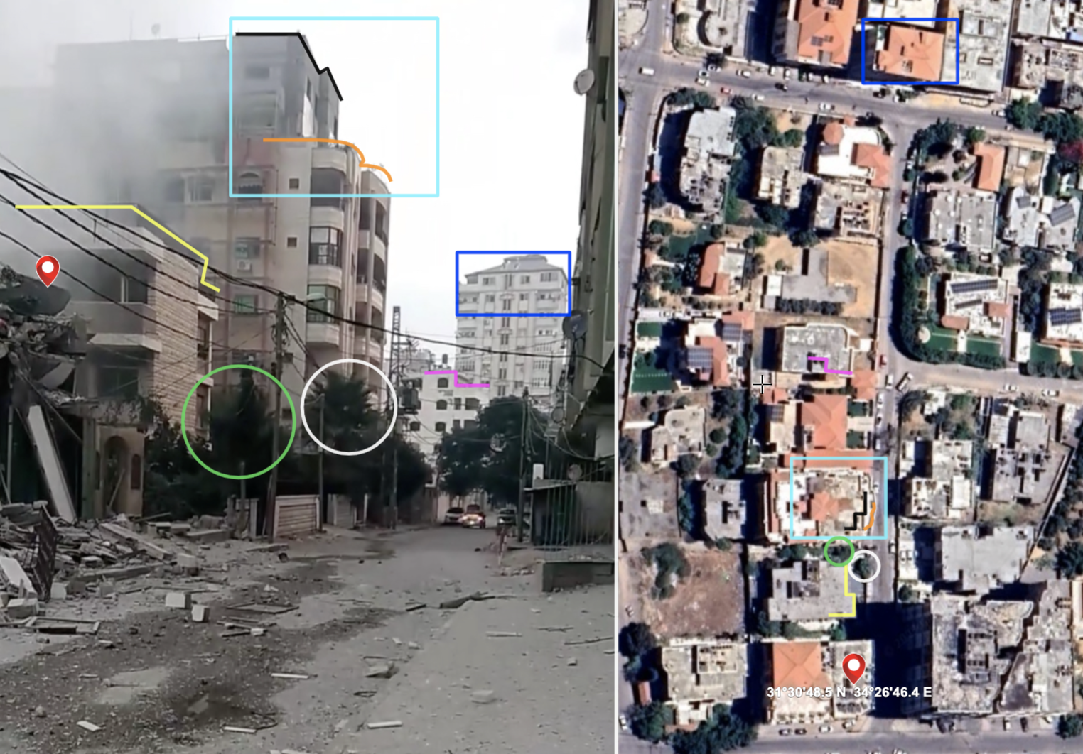
On the left is a screenshot taken from a video posted on Facebook on October 8, 2023, showing the aftermath of the bombing of the Al-Aqsa Building. On the right is a satellite image from Google Earth of the area where the building is located in Al-Rimal neighborhood, coordinates: (31°30’48.5″N, 34°26’46.4″E).
We were able to pinpoint the geographical location of the Al-Aqsa Building using the OpenStreetMap, which indicates that it is situated on Madhat Al-Wahidi Street, in the Thalatheeni neighborhood, Al-Rimal district, north of Gaza.
By searching through social media, we found a series of videos posted by a resident of the area where the Al-Aqsa Building is located, on Facebook, on October 8, 2023. We verified these videos through a reverse search process using search engines.
Through geographical matching of a screenshot taken from one of the posted videos with a satellite image from Google Earth of the area, we were able to document the geographical coordinates of the Al-Aqsa Building: (31°30’48.5″N, 34°26’46.4″E).
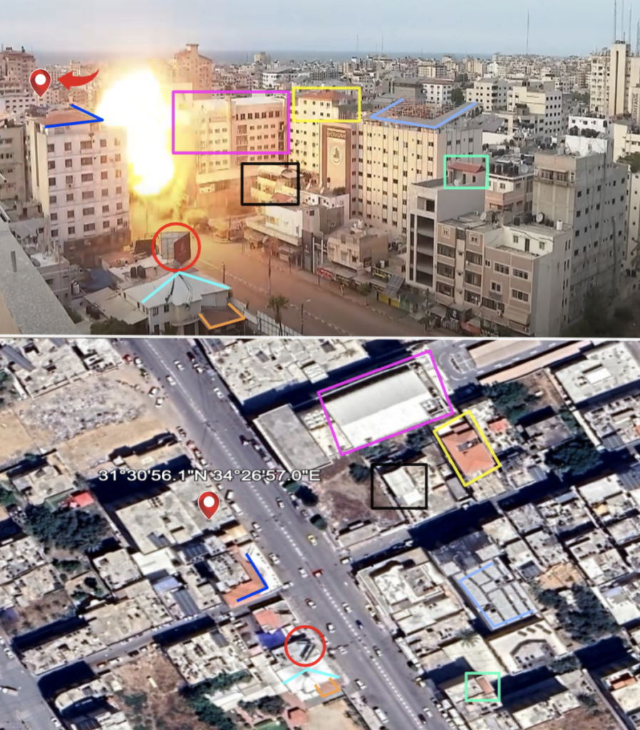
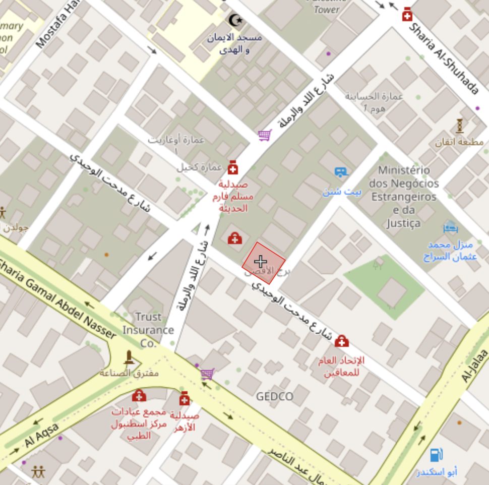
The marked signs in the two images indicate geographical alignment. At the top: a screenshot from a video capturing the moment of the Islamic National Bank being bombed Source: Al Jazeera
During a live broadcast on October 8, 2023, Al Jazeera’s camera captured the moment when Israeli aircraft bombed the Islamic National Bank located on Omar Al-Mukhtar Street in the Rimal neighborhood, north of the Gaza Strip.
We verified the geographical location of the area depicted in the video and documented the coordinates of the bank: (31°30’56.1″N, 34°26’57.0″E) through geographical matching between a screenshot taken from the video showing the moment of the bombing, and another image of the area where the bank is located using satellite imagery (Google Earth).
![]()
Khan Yunis (October 9)
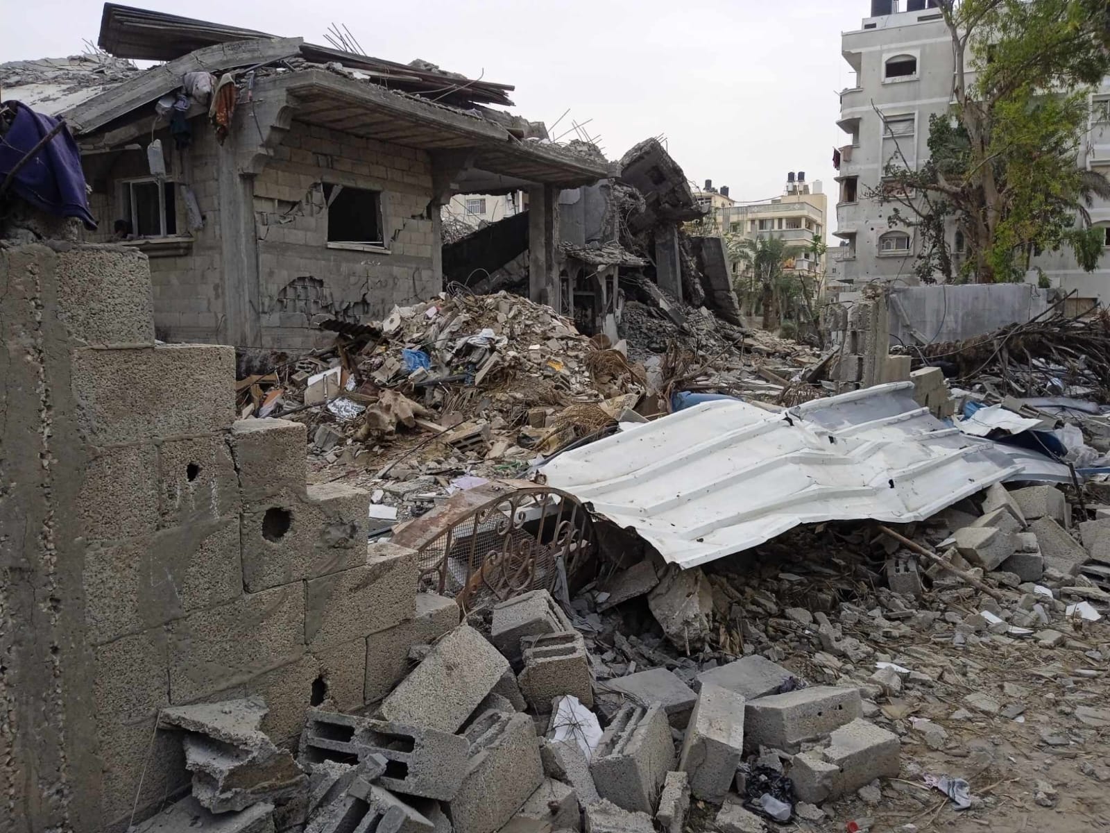
Part of the destruction inflicted upon the home of the Astal family in Khan Yunis following an Israeli airstrike. (Photo by: Hala Astal)
Residents of the Abasan Al-Kabira and Abasan Al-Saghira areas, located east of Khan Yunis, received instructions on October 8th and 9th to evacuate to the central area of Khan Yunis, designated as a safe zone, as announced by the Israeli army spokesperson Avichay Adraee on his official Facebook page.
Contrary to these instructions, on the afternoon of October 9th, Israeli airstrikes targeted the residential square of the Astal family in central Khan Yunis without prior warning, as informed by Hala Astal. This occurred despite the Israeli army declaring Khan Yunis as a safe area at that time.
During our conversation, Hala stated: “There was no alert or warning. My family’s three-story house collapsed suddenly on them on the afternoon of October 9th.” The Israeli airstrikes on the Astal family’s home resulted in the death of the 16-year-old child Amro Astal, in addition to five others from neighboring houses.
Hala explained that the majority of the martyrs were children and women, noting that more than 30 people were injured in this bombing, in addition to the damage to her family’s home and surrounding neighbors’ houses.
She added that the Astal family has lost 103 individuals – as of November 2023 – due to Israeli airstrikes targeting their homes in various geographical areas in Gaza.
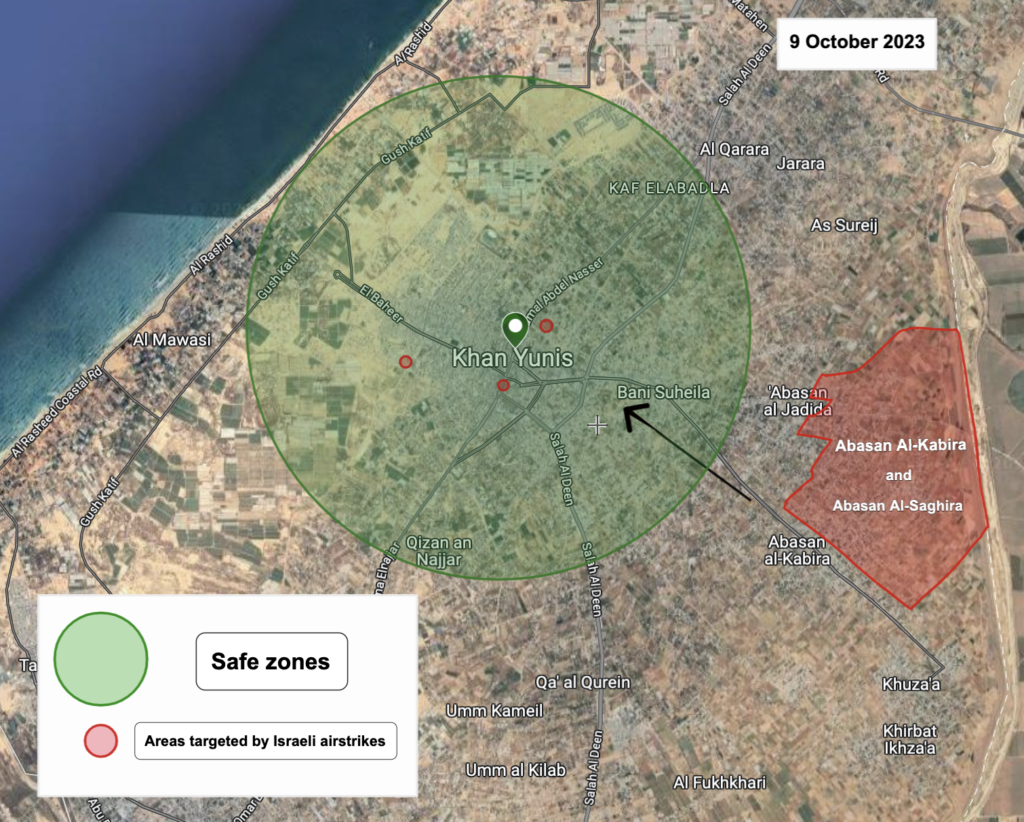
A map illustrating the areas targeted by Israeli airstrikes in Khan Younis on October 9, 2023, despite it being a safe zone according to a map published by the Israeli army. Source: Maps published through the spokesperson for the army Avichay Adraee on Facebook.
By tracking the Israeli airstrikes that occurred on October 8th and 9th, through the data provided by the Palestinian Center for Human Rights and several local Palestinian media outlets, we were able to identify three areas targeted by Israeli airstrikes on October 9th, located within the boundaries of Khan Yunis.
The documented and geographically identified targets within Khan Yunis included the Astal family home, the Hileh family home, and the Old Khan Yunis Municipality building.
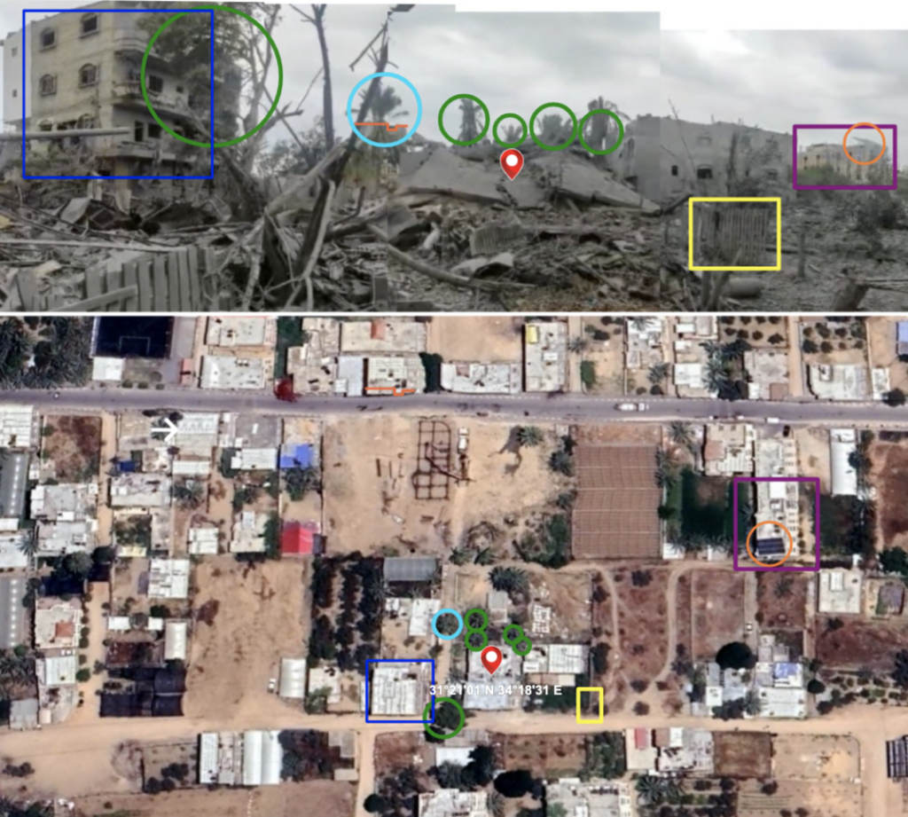
The marked signs indicate a geographical match between the image at the top, obtained from a video posted on the TikTok application showing the aftermath of the Israeli airstrike on the residential square of the Astal family in Khan Yunis, and the satellite image (Google Earth) at the bottom
We learned through communication with Hala Al-Astal that the family’s house is located near the Walid Al-Aqad Museum. We identified a video posted on TikTok on October 10th, showing the aftermath of the airstrike on the Astal family’s home, through reverse search on search engines.
We were able to determine the coordinates of the house: (31°21’01” N, 34°18’31” E), located on Museum Street, near the Walid Al-Aqad Museum, in central Khan Yunis, through geographic documentation and comparison between a screenshot taken from the published video and another image of the residential square obtained using satellite imagery (Google Earth).
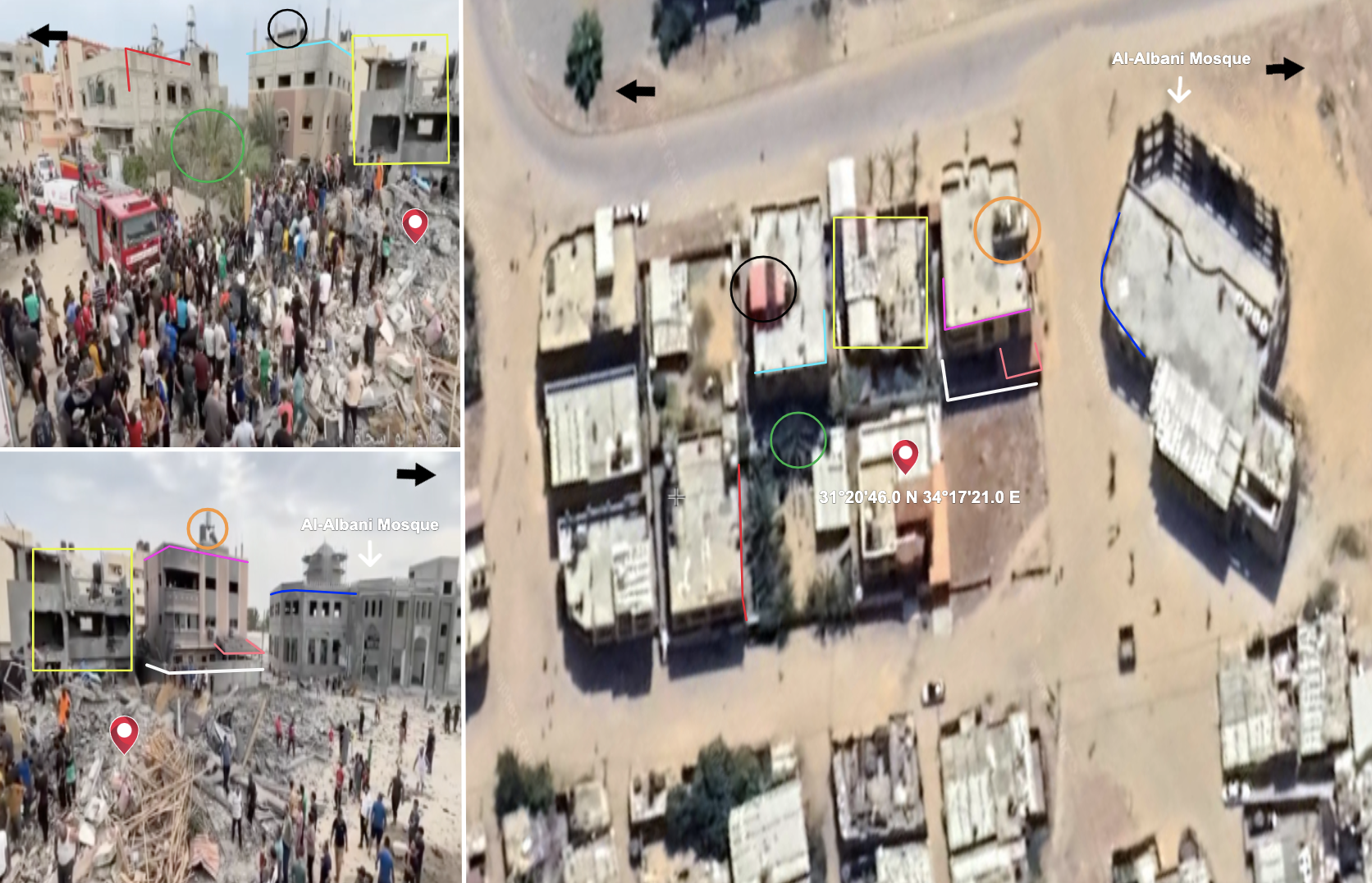
The marked indicators demonstrate the geographic alignment between the satellite image from Google Earth and two screenshots taken from a video posted by the journalist Tareq Abu Issa on October 9th. They illustrate the effects of the bombardment in the area where the Hileh family’s house is located in the Namsawi neighborhood of Khan Yunis
We observed a video posted by journalist Tareq Abu Issa on October 9th via Facebook, showing the aftermath of the bombing of the Hileh family’s house. We verified the video through reverse search using various search engines. Additionally, we came across images published by journalist Amro Tabsh on October 9th, depicting the destruction in the area.
We determined the coordinates of the house: (31°20’46.0″, 34°17’21.0″), located near the Al-Albani Mosque, in the Namsawi neighborhood of Khan Yunis, through geographic documentation and comparison between two screenshots obtained from the video and another image of the area using Google Earth satellite imagery.
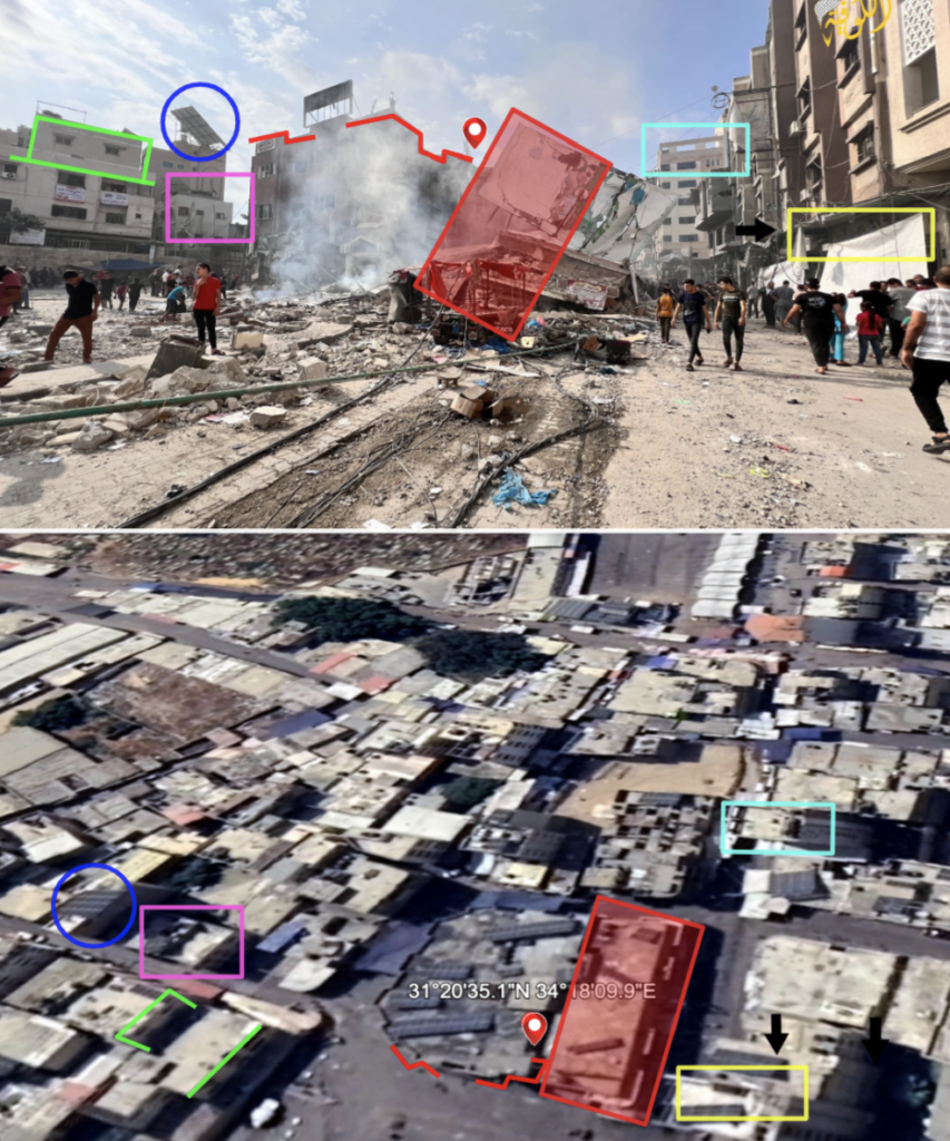
The Old Khan Yunis Municipality Building… The marked signs demonstrate the geographical alignment between the image posted by the photographer Amro Tabsh on Facebook on October 10, 2023, and another image of the municipality building obtained through satellite imagery from Google Earth
We observed photos posted by photojournalist Amr Tabsh on Facebook on October 10, 2023, showing the aftermath of the bombing of part of the Old Khan Yunis Municipality Building. We verified the photos through reverse image search on various search engines.
We determined the coordinates of the municipality building: (31°20’35.1″, 34°18’09.0″), located near the Grand Mosque in central Khan Yunis, by matching one of the photos posted by photographer Amr Tabsh on Facebook with another image of the building using satellite imagery from Google Earth.
![]()
Al-Mawasi (October 18, 21, and 30)
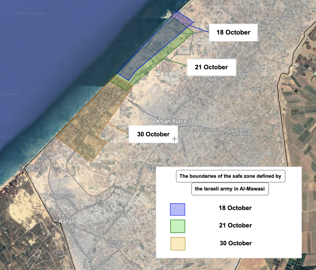
The colors used (blue, green, and yellow) illustrate the variation in the boundaries of the safe zone in Al-Mawasi, as defined by the Israeli army according to three sequentially published maps. Source: Israeli Army Spokesperson’s Facebook page
Since October 18th, the Israeli army has been calling on the residents of northern Gaza to head to the Al-Mawasi area located in the far west of the Gaza Strip.
Al-Mawasi is an agricultural area located southeast of the Gaza Valley, along the coastal strip, stretching for about 14 kilometers from Deir al-Balah in the north through Khan Yunis Governorate to Rafah Governorate in the south, with a depth of approximately one kilometer.
By following the guidelines and redrawing the three maps published by the Israeli army for the Al-Mawasi area, referred to as the “Humanitarian Zone,” we observed differences in the parts designated by the army within the Al-Mawasi area as safe zones.
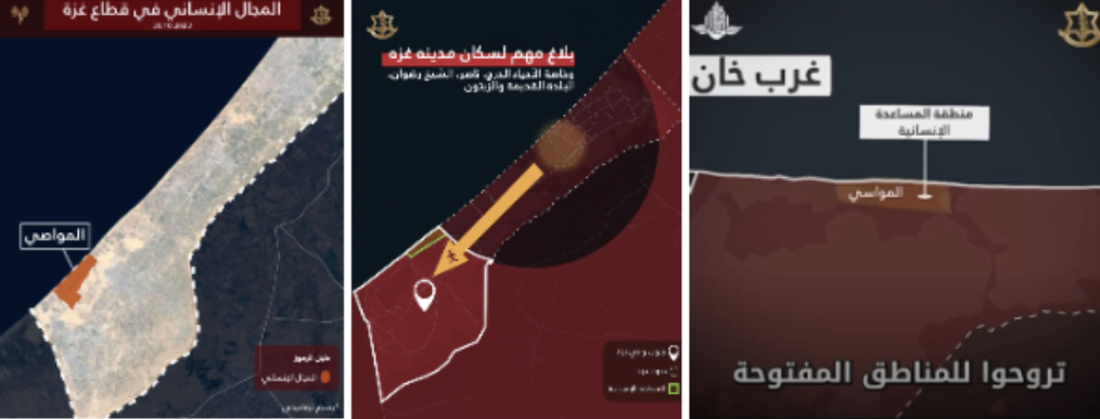
The spokesperson for the Israeli army published a video on October 18th that included a map delineating part of the Al-Mawasi area as a safe zone. Three days later, another map with different boundaries was published, and then on October 30th, another map was released specifying different parts without acknowledging the change.
Susan Abu Daqqa and her family were among the displaced from the Abasan al-Kabira area to the Al-Mawasi area in mid-October, following instructions from the Israeli army to evacuate the area.
Abu Daqqa and her family fled to a friend’s house to save their lives after their residential area east of Khan Yunis was subjected to incendiary balloons and continuous shelling, according to her.
The house where Abu Daqqa’s family sought refuge is located on the Mediterranean coast, where the coasts and the port of Khan Yunis are continuously targeted, she said, adding that “there is no safe area” even inside Al-Mawasi.
In mid-November, the Director-General of the World Health Organization, Tedros Adhanom Ghebreyesus, described the proposal to establish the so-called “Safe Zone” as a “disaster.”
In his statement during the informal general session of the United Nations General Assembly held on November 17th, he stated that the World Health Organization would not participate in the establishment of the so-called “Safe Zone” in Gaza without a broad agreement and unless basic conditions were provided, along with a mechanism to oversee its implementation.
![]()
Rafah (from October 13th to November 20th)
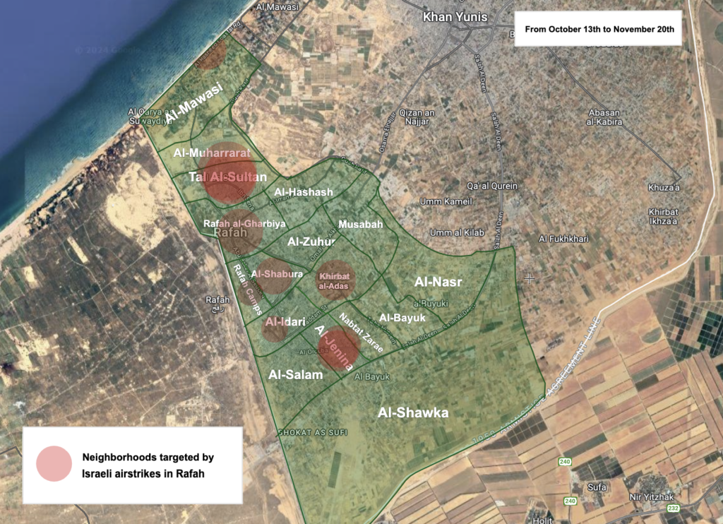
A map of the Rafah area illustrating the neighborhoods targeted by Israeli airstrikes (from October 13th to November 20th). Source: Rafah Municipality page, local media
On the morning of November 19th last year, the Jinina neighborhood in Rafah woke up to the tragic loss of a mother and four of her children, following an Israeli airstrike that targeted the Abu Khatla family home located south of the Gaza Strip. However, the fifth child survived after being thrown by the force of the rocket blast about 20 meters away from the house.
The neighboring Al-Akhars family home was also not spared from the effects of the bombardment, as a portion of the second floor collapsed onto some of the displaced people inside, resulting in one young man sustaining an injury to his foot, as informed by Amna Al-Akhars, a member of the family.
The Al-Akhars house shelters three families, totaling nearly 60 individuals, who fled in search of a safe haven for themselves and their children, according to Amna, as the Israeli airstrikes extended across the northern, central, and southern parts of the Gaza Strip.
The Abu Khatla house is one of 25 homes that were targeted in the Rafah area, located at the southernmost tip of the Gaza Strip, along with two municipal buildings, between October 13th and November 20th. This information was tracked through monitoring the news updates on the Rafah Municipality page on Facebook and corroborated through reports published by local media outlets, along with monitoring condolence posts shared by the families of the martyrs on Facebook.
![]()
We identified the timeframe for monitoring Israeli airstrikes on the city of Rafah from the beginning of the Israeli army’s calls for Gaza residents to evacuate to the southern area on October 13th, until November 20th, just days before the ceasefire took effect on November 24th.
![]()
According to the geographic monitoring of Israeli airstrikes on the city of Rafah, we found that the frequency of the bombardment – during the aforementioned period – was concentrated in the Al-Jenina neighborhood, where the neighborhood witnessed the bombing of 7 houses without prior warning, followed by the Tel Al-Sultan neighborhood, which was struck with 6 houses.
Ahmed Al-Arja, a resident of the Al-Jenina neighborhood in Rafah, tells us that the bombing targets everywhere and at all times, adding: “Every day we say today is the hardest, then we find the next day even harder and more intense.”
He points to the increasing numbers of displaced persons flocking to the south to escape the bombing, as his house accommodates about 10 families, some of whom are displaced families.
According to a statement by the United Nations Relief and Works Agency for Palestine Refugees (UNRWA) in December last year, since the start of the war, Israel forcibly displaced more than 1.8 million residents of Gaza from their homes, especially from the northern parts of the Gaza Strip, claiming that the south is safer, according to UNRWA.
It noted that more than 200 people who sought refuge in UNRWA facilities were killed, and nearly 1,000 Palestinians were injured, explaining that most of these shelters are located in the central and southern areas of the Gaza Strip, which were believed to be safe areas.
Since the beginning of December last year, Israeli army spokesman Avichay Adraee announced, through several posts on his official Facebook page, what he called a “temporary tactical suspension of military activities” for humanitarian purposes in Rafah in areas (Al-Jenina neighborhood, Al-Salam neighborhood, Al-Gharbi neighborhood, Tel Al-Sultan neighborhood, Rafah Camp) without specifying the nature of this activity.
Speaking to three residents of Rafah from the neighborhoods of Al-Jenina, Tel Al-Sultan, and Al-Gharbi, they told us that they did not receive any posts or warnings from the Israeli army
regarding the bombing of the area or any military operations in it.
![]()
Targeting Civilians
After more than 100 days of the Israeli war on the Gaza Strip, the number of martyrs has risen to more than 28,000 martyrs as of the writing of this investigation on February 16, 2024. Among them, approximately 70% are children and women, according to data from United Nations organizations, in addition to about 66,000 wounded, according to the latest statistics announced by the Palestinian Ministry of Health in Gaza.
The Israeli Air Force carried out nearly 10,000 airstrikes on the Gaza Strip, as announced by the Israeli army in a statement published in early December.
The Euro-Mediterranean Observatory for Human Rights said on the sixtieth day of the aggression on Gaza in December last year that the Israeli army’s claim that every armed individual led to the killing of two civilians is a “false claim”.
According to preliminary statistics provided by the Observatory, based on field documentation, at least nine out of 10 Palestinian deaths resulting from Israeli attacks are actually civilian deaths.
Israeli army spokesman Daniel Hagari said that the army warns civilians before attacks, whenever possible, pointing out that they temporarily direct civilians away from areas of intense fighting.
He added in a statement published on the official website of the Israeli army on December 18: “We abort attacks when we see unexpected civilian presence. We choose the right munition for each target, so it doesn’t cause unnecessary damage.”
The Israeli army published on its official website statistics on the number of evacuation leaflets dropped on the Gaza Strip, which reached 1,524,000 leaflets, in addition to about 19,734 phone calls to Gaza residents.