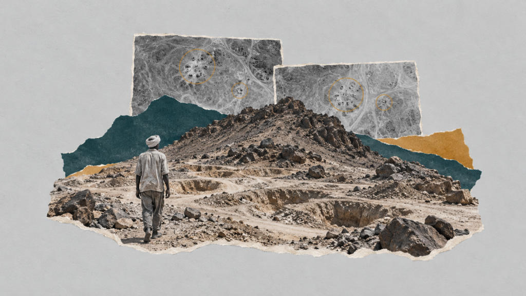
Satellite images analysed by Zawia3 show an unusual change at two gold-mining sites 308 kilometres apart, occurring within the same 48-hour period in which survivors said a fighter jet bombed their mine on the morning of Saturday, 10 October. One site is inside the Halaib Triangle; the other is in the Eastern Desert, southwest of Marsa Alam.
At 10:24 a.m. Sudan time on Saturday, 10 October 2026, the European Sentinel-2A satellite passed over a rocky valley dotted with mining pits, 8.7 kilometres north of the 22nd parallel inside the Halaib Triangle. Its sensors recorded a dark patch of approximately 4,400 square metres in the heart of the valley that had not been there 48 hours earlier. Roughly two and a half hours before that, according to miner Abdel Aziz Youssef’s account to Agence France-Presse, a fighter jet appeared overhead and “struck five times”.
Some 308 kilometres to the north, inside Egyptian territory southwest of Marsa Alam, the same satellite recorded a second dark patch of approximately 2,800 square metres within the same time window, at a location inside a state gold-mining concession.
Zawia3 re-examined the published reporting on the 10 October strikes, from witness accounts and casualty figures to open-source analyses and official statements, and retained the raw data for 31 satellite scenes of the two sites between 1 September and 18 October. This report sets out what could be established, what remains attributed to its sources, and what requires fieldwork that images cannot provide.
The investigation tests a specific question: how far do satellite images and published documents support accounts of the attack on the miners, and what can be established about the Eigad and Hangaliya sites and the timing of the changes there? Zawia3’s contribution consists of measuring these changes through a time series, testing them against earlier scenes, and matching the Hangaliya location to the concession boundaries recorded in documents, while separating those findings from conclusions about what caused the traces and who was responsible.
A dark patch appeared at both sites between the mornings of 8 and 10 October. No comparable darkening appeared between 3 and 8 October.
Saturday morning in North al-Wadi
Miners call the area “North al-Wadi” and the mountain whose slopes they work “Jabal al-Uqaydat”. Some call it “the Red Mountain”, according to witnesses interviewed by BBC Arabic. Miner Mirghani Malik was among the first to describe what happened, speaking that same night to Sudan Tribune. He said fighter jets had carried out at least five strikes on the al-Uqaydat mine, at least 20 injured people had been taken to al-Ansari market, and hundreds of workers had fled into the mountains without water or supplies.
The following day, AFP quoted miner Abdel Aziz Youssef as saying a fighter jet appeared at around 8 a.m. and struck five times. Survivor Sharaf Ali said thousands of workers were at the site when the strike hit, and those who fled scattered, leaving nobody able to establish the death toll. Miner Ali Muhammad Hamza told Africanews that the aircraft circled three times and struck on its fourth pass while he was making tea. Omar Muhyial Din Abdallah said the first strike exploded among the miners, and that he lost his brother and two cousins. In a later report, a survivor named Omar Muhyial Din told AFP that he had seen an Egyptian flag on the aircraft.
The accounts differ on the time: 6 a.m., according to three survivors interviewed by Sudan Tribune; 8 a.m., according to AFP and Africanews; and 10 a.m., according to a witness interviewed by the Ayin Network. BBC Arabic quoted miner Bahr al-Din Muhammad as saying one strike killed 35 miners at once, but dated the strike to Friday, unlike most sources. Witness Bahr al-Din Hassan told The New York Times, according to a republished copy of its report, that aircraft bombed the site at least three times over an hour beginning around 9 a.m., and that about 35 people were killed in the first strike. This matches the BBC account, and the two witnesses may be the same person. A survivor told Atar Network that a strike occurred at 11:20 a.m. and that the bombing lasted more than three hours. The accounts agree that the attack came from the air, but vary between one and five strikes.
Between six and eleven in the morning: accounts differ on the time of the strikes, but almost all place them on Saturday, 10 October.
Times and sources of the witness accounts: the following two charts show where the accounts differ, without assuming that all are independent testimonies.
What the satellites recorded
Zawia3 was not the first to compare satellite images. On 12 and 13 October, analyst Faisal Elsheikh posted coordinates for the two sites on X, crediting the account tom_bike. According to his post, he relied on terrain matching, witness accounts and a comparison of two European satellite images from 8 and 10 October. The Sudanese Echo account then used the same coordinates on 14 October, and Atar Network published a comparison of two images of each site on 15 October, dating its first Eigad image to 3 October. These were, however, visual comparisons of processed-colour images before and after the event, without measurement or comparison with preceding weeks.
Zawia3 retained the raw data for every clear satellite scene of the two sites from 1 September onwards. In each scene, it measured the ratio of light reflectance within a circle 70 metres in diameter around the location of the change to reflectance in the surrounding ground. At Eigad, this ratio remained almost stable across nine scenes captured by three different satellites between 3 September and 8 October, before suddenly dropping by 12.2 per cent in the 10 October scene. At Hangaliya, it remained stable across 14 scenes, then dropped by 10.6 per cent on the same day. The drop is approximately eight times the usual measurement fluctuation at Eigad and about nine times that at Hangaliya.
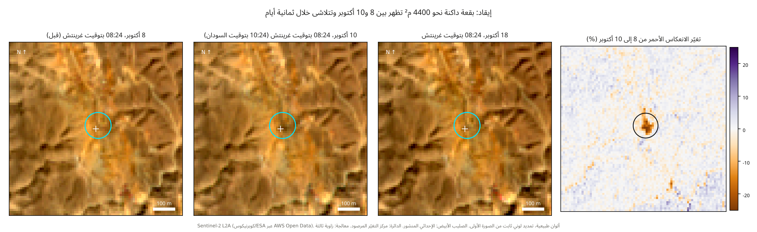 Eigad: a dark patch of about 4,400 m² appears on 8–10 October and fades within eight days8 October, 08:24 UTC (before)10 October, 08:24 UTC (10:24 Sudan time)18 October, 08:24 UTCRed reflectance change, 8–10 October (%)Sentinel-2 L2A (Copernicus/ESA via AWS Open Data). Natural colours; fixed stretch from the first image. White cross: published coordinate. Circle: observed change centre. Processed by Zawia3.
The measurement narrows the window in which the trace suggested by Elsheikh’s comparison appeared, and adds a test of the preceding period. The difference between 3 and 8 October reveals no comparable darkening near either point. No significant change appeared near the Hangaliya point, while only two small changes appeared at Eigad: darkening across about 400 square metres and brightening across about 700 square metres, 55 to 85 metres from the coordinate. Neither overlaps the patch that appeared later, and both are consistent with new excavations. The change at each site therefore appeared between the satellite’s pass on Thursday, 8 October, and its pass on Saturday, 10 October: around 08:24 UTC at Eigad and 08:23 at Hangaliya. This is a shared observation window of approximately 48 hours, not evidence that the changes occurred at the same instant or had the same cause. Since Saturday’s image was captured at Eigad at 10:24 a.m. Sudan time and at Hangaliya at 11:23 a.m. Egyptian time, it records only what happened before those times and cannot establish what happened afterwards; an Atar witness placed one strike at 11:20 a.m.
The traces subsequently developed differently. At Eigad, the darkening diminished to 4.1 per cent after three days, and the red-reflectance ratio returned to its usual level on 18 October. At Hangaliya, darkening remained between 6.2 and 8.4 per cent through the last image. The spectral signature at both sites is broad darkening across visible and infrared bands, consistent with ash, soot or dark debris. The analysis interpreted it as less consistent with soil wetted by mining water. That assessment does not, however, conclusively rule out wetting alone or identify the material responsible for the darkening.
A dark patch of approximately 4,400 m² at Eigad and 2,800 m² at Hangaliya, each less than 35 metres from the published coordinate.
A resolution of ten metres is insufficient to distinguish a bomb’s trace from a fire started on the ground or a concentration of dark objects such as tents and vehicles. Moreover, Elsheikh identified the two coordinates through terrain matching and satellite comparison. Zawia3’s work is therefore an independent replication and measurement of the satellite observation and a test of its timing, not an independent geolocation of the strike from video footage. Within a six-kilometre radius of Eigad, this patch showed the strongest change and was the only one of its size with a signature of broad darkening. Other changes, including larger clusters, involved brightening or mixed changes.
The time comparison tests whether the change falls within the site’s usual fluctuations. It cannot, on its own, distinguish bombing from a ground fire or a change in mining activity. Measuring the affected location relative to its surroundings reduces the effect of general lighting differences, without eliminating every possible effect of local shadows, viewing angles or surface properties. Interpreting the two patches therefore remains dependent on witness accounts and other evidence. Higher-resolution images or field verification are still needed to establish their cause.
Hangaliya: a second trace inside a state concession
No published witness has described what happened at Hangaliya, and no media outlet has published a field account of a strike there. Reporting has relied on satellite comparisons and circulating videos. The site lies approximately 315 kilometres north of the 22nd parallel, in a flat valley surrounded by rocky hills, about 900 metres from the old “Hangaliya mine” recorded on open maps.
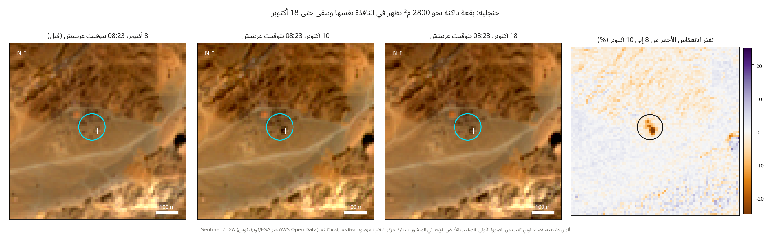 Hangaliya: a dark patch of about 2,800 m² appears in the same window and remains through 18 October8 October, 08:23 UTC (before)10 October, 08:23 UTC18 October, 08:23 UTCRed reflectance change, 8–10 October (%)Sentinel-2 L2A (Copernicus/ESA via AWS Open Data). Natural colours; fixed stretch from the first image. White cross: published coordinate. Circle: observed change centre. Processed by Zawia3.
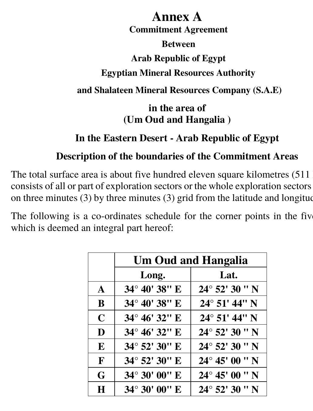
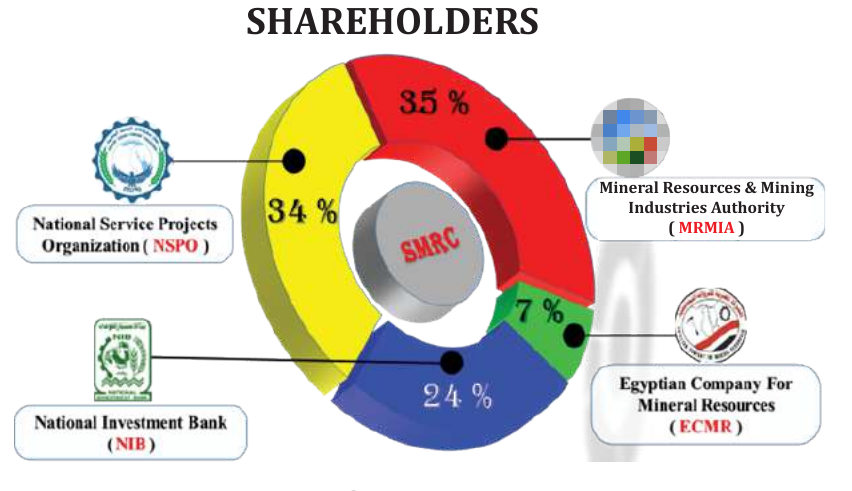
The location of the change lies inside the “Hangaliya and Umm Ud” concession defined in the annex to Law 167 of 2021, which authorised the minister of petroleum and mineral resources to contract with the Egyptian Mineral Resources Authority and Shalateen Mineral Resources Company to explore for and exploit gold across approximately 511 square kilometres. According to the company brochure, ownership is divided between the Mineral Resources Authority (35 per cent), the armed forces’ National Service Projects Organisation (34 per cent), the National Investment Bank (24 per cent) and the Egyptian Company for Mineral Resources (7 per cent). The brochure presents a 2026 plan that includes more than 2,000 samples in northern and southern Hangaliya, ahead of a drilling programme.
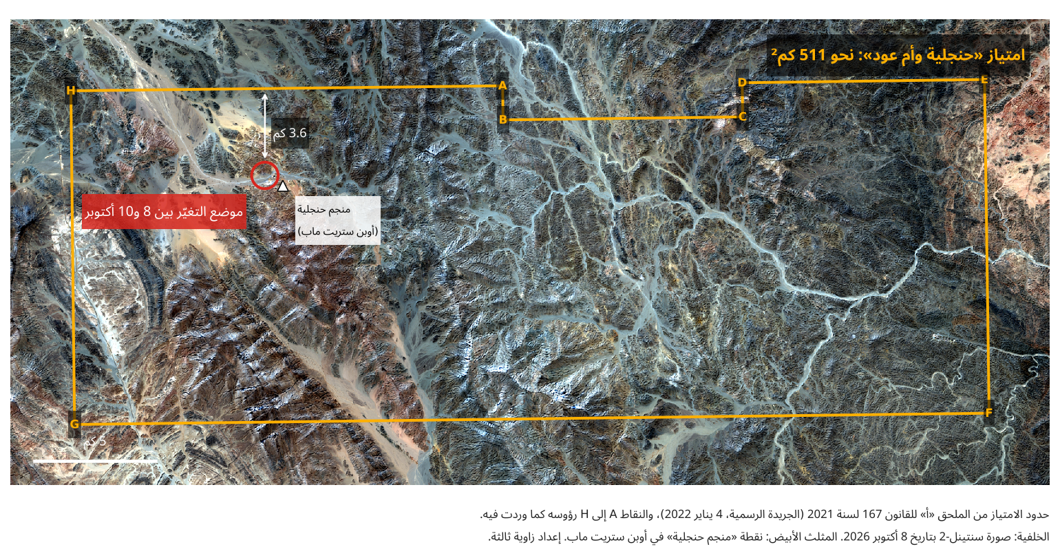 Hangaliya and Umm Ud concession: approximately 511 km²3.6 kmChange location, 8–10 OctoberHangaliya mine
(OpenStreetMap)5 kmConcession boundaries: Annex A to Law 167 of 2021 (Official Gazette, 4 January 2022). Vertices A–H follow the annex.
Background: Sentinel-2, 8 October 2026. White triangle: OpenStreetMap Hangaliya mine point. Prepared by Zawia3.
Activists circulated a video filmed from higher ground showing a mining camp of dozens of huts at the foot of rocky hills, with a building burning and black smoke rising. It carries the words “Hangaliya now, Saturday morning”. We did not find the original upload and have not yet matched its location. We saw it only as an excerpt in a Sudanese Echo montage.
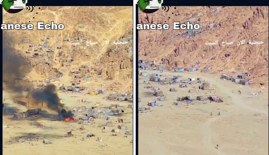
A post by Sudanese Echo on X on 14 October, containing the montage in which the clip attributed to Hangaliya appeared.
On 14 October, the Egyptian outlet Egypt Telegraph compared circulating videos, including a TikTok clip ending with the words “Goodbye, Hangaliya”, with the terrain around the Hangaliya mine on Google Earth, without publishing coordinates. The account @alipolitics1, cited by Elsheikh in his Hangaliya post, published a video it said had been filmed on 30 September, showing miners leaving Hangaliya in response to the army. On 17 October it published a photograph it said showed Egyptian warning notices. We have not verified the date of either. By contrast, Ayin captioned a satellite image apparently showing Hangaliya as “Sites of Egyptian airstrikes inside Sudanese borders”, although its coordinates are inside Egypt.
A video posted by @alipolitics1, who said it was filmed on 30 September and showed miners leaving Hangaliya. We have not verified its date.
A photograph posted by the same account on 17 October, which it said showed Egyptian warning notices. We have not verified its date.
No evidence presented in this investigation links the company or its shareholders to any security operation. The site’s presence within the concession does not establish a motive or a decision. The match identifies the site’s geographical and contractual status; it does not in itself establish the company’s connection to, or knowledge of, the attack. According to Asharq, the armed forces’ June statement referred to operations “near the Marsa Alam–Edfu road”, the road leading to the Hangaliya mine according to the company brochure. It also referred to networks intimidating workers at Egyptian and foreign mining companies. We have not examined the original text of that statement.
The location of the change at Hangaliya falls inside the Hangaliya and Umm Ud concession, 3.6 kilometres from its nearest boundary.
Where is Eigad?
The name “Eigad” came from the place-name database maintained by the US government, where “Jabal Eiqaat” appears in several forms approximately four kilometres from the published coordinate. The name sounds close to “al-Uqaydat” when pronounced with the Sudanese qaf. However, this identification, along with the label “North al-Wadi mine” on OpenStreetMap, was added by a single user on 11 and 12 October, after the incident.
Supporting this identification are Elsheikh’s naming of the site “Jabal Eiqaat” on 11 October using a terrain-matching tool, a circulating clip attributed to the strike site carrying the words “Jabal Eigad and the White Mountain, North al-Wadi”, and Elsheikh’s June identification of the first strike site only half a kilometre from the October point. On 21 October, AFP used Planet Labs images and three survivors to locate the October strike at Jabal al-Uqaydat inside the Halaib Triangle, within a 176-square-kilometre concession granted by the Egyptian government to an unnamed state gold-mining company, without publishing coordinates. Other sources, however, place al-Uqaydat elsewhere. In June, Mada Masr described it as north of the Halaib Triangle and treated the Red Mountain as a neighbouring mountain. Atar quoted a source as saying the June strike on al-Uqaydat took place 20 to 30 kilometres south of the border. Eigad and al-Uqaydat are likely names for the same area, but witness confirmation is still needed.
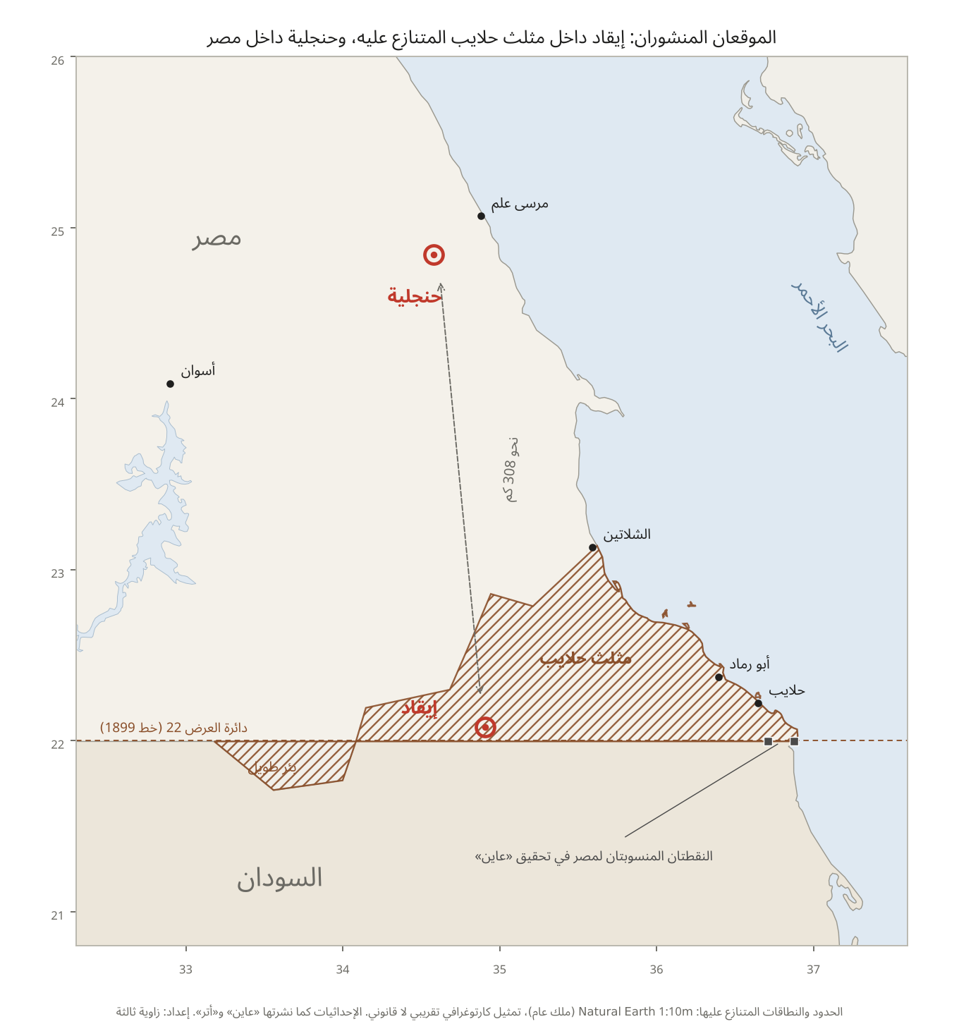 Published sites: Eigad in the disputed Halaib Triangle; Hangaliya inside EgyptEgyptSudanMarsa AlamAswanHangaliyaRed SeaApprox.
308 kmShalateenHalaib TriangleAbu RamadHalaibEigad22nd parallel (1899 line)Bir TawilTwo points attributed to Egypt in Ayin’s investigationBoundaries and disputed areas: Natural Earth 1:10m (public domain). Approximate cartographic representation, not a legal determination.
Coordinates as published by Ayin and Atar. Prepared by Zawia3.
The following charts help explain the disagreement over location and distances, distinguishing published coordinates from approximate map boundaries.
The coordinate lies 8.7 kilometres north of the 22nd parallel, inside the Halaib Triangle, which Egypt administers and Sudan claims. At its longitude, it is approximately 77 kilometres south of the 1902 administrative line, according to the UK Permanent Committee on Geographical Names reference and Natural Earth boundaries. The conflicting accounts draw on this ambiguity: Emergency Lawyers said the strike occurred “inside Sudanese territory”, while the Egyptian military statement said the campaign was taking place “within the borders of the Egyptian state”. More precisely, the site lies in disputed territory administered by Egypt.
Al-Ansari market, where the wounded were taken, lies 45 kilometres south of the coordinate and south of the 22nd parallel, meaning it is inside Sudan under either boundary line. The two checkpoints that Ayin’s investigation attributed to the Egyptian army lie on the Red Sea coast, 186 and 204 kilometres from the strike site, and approximately 320 and 400 metres south of the 22nd parallel. That margin is finer than the accuracy of the available boundary sources. The investigation said they had existed “since the start of the war”, but high-resolution archive images show they were present by at least 2021, before Sudan’s war began. We have not verified their identity.
The toll: twelve figures, no list of names
At least twelve casualty figures emerged from different sources, without any organisation publishing a list of victims’ names. Among the earliest was the Sudan Doctors Network’s announcement of 13 dead and 28 injured, reported by the Associated Press on 11 October. The same day, Emergency Lawyers posted a figure of 72 dead on X “according to preliminary information”. It became the most widely circulated number after AFP, Reuters and Al Jazeera reported it. On 18 October, The Guardian attributed a figure of 114 to the same organisation. We have not found that figure in any other source.
| Figure | Category | Original source | Outlet consulted | Date |
|---|---|---|---|---|
| 13 and 28 | Dead and injured | Sudan Doctors Network | Associated Press | 11 October |
| 72 | Dead | Emergency Lawyers (X post) | AFP, Reuters, Al Jazeera | 11 October |
| More than 200, and hundreds injured | Dead and injured | Three unnamed survivors | Sudan Tribune | 11 October |
| About 200, and 120 injured | Dead and injured | Darfur Victims Support | BBC Arabic | 12 October |
| More than 60, and about 150 injured | Dead and injured | Witnesses and local sources | BBC Arabic | 12 October |
| 85 | Dead | Academic Osama Ahmed Eidrous, without a source | Al Jazeera | 12 October |
| At least 65, and more than 120 injured | Dead and injured | Two witnesses | The New York Times (via a republished copy) | 12 October |
| 30 | Dead in the first wave | Miner Hamed al-Ali | Ayin | 13 October |
| 158, and more than 60 injured | Dead and injured | El Fasher Resistance Committees Coordination, according to Sudanese Echo alone | Sudanese Echo | 14 October |
| 150 to 250 | Estimate | Unnamed health official | Ayin | 15 October |
| 100 to 200 injured, including 18 at Atbara Hospital | Injured | Unnamed medical source | Atar | 15 October |
| 114 | Dead | Emergency Lawyers, according to The Guardian alone | The Guardian | 18 October |
These figures must not be added together or read as an increasing cumulative toll. Some came from the same organisation on two dates; others rely on the same survivors speaking to several media outlets. The most that can be said is that the Sudan Doctors Network announced 13 dead the following day, The Guardian later attributed at least 114 to Emergency Lawyers, and witnesses’ estimates ranged from dozens to more than 200.
The following charts show the reported deaths and injuries and how the figures were relayed, organised by source. They must not be combined into a single toll.
Only a few names appeared in the reporting: al-Tayeb al-Hadi Ahmed Hamed, 16, who Ayin said died later; and Othman Omar Abdel Razek and Omar Abkar Abdel Razek, from Wad al-Hilou in Kassala state, according to AFP photo captions (using the source’s English spellings). We have not independently verified any of these names.
No list of names: published figures range from 13 deaths announced by the Sudan Doctors Network to more than 200 according to witnesses.
A video, the earliest copy we found of which was posted by AfriMEOSINT on X on the evening of 11 October, showed rows of bodies wrapped in blankets and tied with ropes on a slope, a burnt patch of ground alongside them and dozens of workers around them. Zawia3 downloaded the clip and saved its digital hash. Its low resolution does not allow a confident count of the bodies, and its filming location has not yet been established.
Warning: the following image and post contain scenes of wrapped bodies.
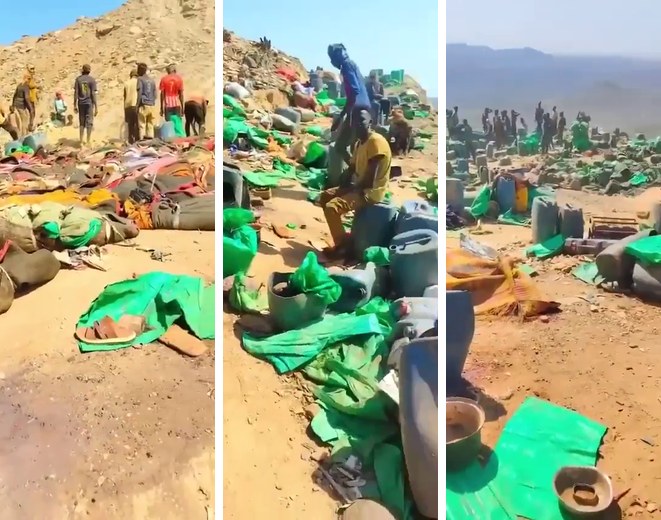
A post by Lastkombo on X on 12 October containing two clips, including the footage of wrapped bodies. Contains disturbing scenes.
The aircraft and the munition
The earliest attribution of the strike to F-16 fighter jets that we found appeared in a post by analyst Faisal Elsheikh on X on 11 October, accompanied by a cropped, blurred frame of a distant aircraft from a circulating video. An Ayin investigation published on 15 October repeated the identification without specifying the frame or the basis for it. We found no published analysis supporting identification of the model. According to a republished copy of its report, The New York Times said it had verified that the clips had not appeared online before Saturday and showed fighter jets flying over the area and munitions hitting the ground, without identifying the aircraft model.
Analyst Faisal Elsheikh’s 11 October post attributing the strike to F-16 fighter jets, with the cropped frame of the aircraft.
As for the munition, the only named expert is Trevor Ball, a former US Army explosive ordnance disposal technician. According to the same newspaper, he saw what appeared to be an unexploded Egyptian Nasr 400 bomb in one clip. An unexploded bomb appeared in a video posted by the Darfur Victims Support organisation (DVSorg) on 12 October, which described it as “missiles” and estimated its weight at around 450 kilograms. Remains of a bomb’s tail and fins appeared in another clip titled “North al-Wadi is bleeding”. On the morning of 12 October, Elsheikh wrote that he had not yet identified the munition. That evening, he described it as “the munition used”, attaching a reference photograph of a Nasr 400 bomb from the CAT-UXO database.
A clip posted by Darfur Victims Support on 12 October, showing an unexploded object it described as “missiles”.
Ayin published the same reference image of an intact bomb against a white background, captioned “Nasr 400-kilogram munition”, without identifying it as a reference image. Its Arabic edition’s cover used a photograph of F-16 fighters carrying Iraqi flags and Iraqi Air Force serial numbers, under the words “Egyptian F-16 fighters”, without saying the image was illustrative. This does not imply Iraqi aircraft were involved, but it disqualifies both images as evidence of the incident.
In any event, a bomb’s country of manufacture, if established, does not identify the platform that carried it or who dropped it. No party has published evidence that the same munition was used at Hangaliya, although Ayin said it was used “in both strikes”. Identification of the aircraft and munition remains attributed to the sources making it until an independent expert examines original images of the remnants.
The aircraft has not been independently identified. Identification of the munition rests on one expert’s assessment of one video.
What Cairo said, and what it did not
The Egyptian authorities have neither acknowledged nor denied responsibility for the strike. Two days afterwards, military spokesman Brigadier General Ahmed Othman Ali issued a statement announcing implementation of “the third phase of the large-scale campaign” against illegal gold-ore mining in the Eastern Desert, involving the armed forces and civilian police, after “dropping warning leaflets on criminal elements”, to enforce sovereignty “within the borders of the Egyptian state”, according to Al-Ahram Gate. The statement mentioned no aircraft, strikes, deaths or specific locations. It reaffirmed relations with Sudan and called on people not to follow “malicious rumours”. According to The New York Times, it stressed that the forces had operated within Egypt’s borders, not on Sudanese territory.
Egyptian officials have, however, spoken outside formal statements. On 12 October, Reuters quoted two Egyptian security officials as saying the strike aimed to end “chaos” on the border and attempts by Egyptian and Sudanese groups to control mining areas. About a month earlier, on 16 September, Border Guard commander Major General Osama Abdel Hamid Dawoud told Al-Hadath that illegal mining had been dealt with firmly in cooperation with the air force and intelligence services, according to Masrawy. In June, two senior Egyptian officials told Mada Masr that Egypt had carried out airstrikes against Sudanese groups that had crossed into Egyptian territory.
On 14 October, Darfur Governor Minni Arko Minnawi met Egyptian Ambassador Yasser Ali Sorour at the embassy in Port Sudan. Sudan Tribune reported, without identifying the source of its account, that the Egyptian side expressed regret over the casualties, offered condolences to their families and affirmed its commitment to uncovering the facts through the ongoing investigation in cooperation with Sudanese authorities. Neither the embassy nor Egypt’s foreign ministry issued a confirmation or denial. On the day of the military statement, Egyptian Foreign Minister Badr Abdelatty and his Sudanese counterpart, Muhyial Din Salem, spoke by telephone and affirmed respect for each country’s sovereignty and borders, according to Egypt Today, without publicly mentioning the strike.
Egypt has neither acknowledged nor denied responsibility for the strike. Reuters quoted two Egyptian security officials explaining its purpose.
The military statement does not resolve the question of warning leaflets. A miner told Ayin that aircraft dropped leaflets near the “Salah” mine, but no leaflet drops were seen in North al-Wadi itself. Survivors told Sudan Tribune that an Egyptian patrol had previously warned the workers. The army did not specify where or when leaflets were distributed.
Khartoum between two committees
On 12 October, Transitional Sovereignty Council head General Abdel Fattah al-Burhan decided to form a fact-finding committee including representatives of the public prosecution, judicial and security bodies, without assigning responsibility, according to Sudan Tribune. The council described what happened as a “tragic incident”, according to BBC Arabic. Burhan had promised a similar investigation after the June strikes in the same area, which killed 23 miners according to a Sudanese medical source who spoke to Mada Masr. Its findings had not been published when the second strike occurred. His foreign affairs adviser, Amjad Farid, described the October strike as an unjustified and unacceptable crime, according to AFP. On 14 October, Minnawi called on both governments to exchange their investigation findings.
On 21 October, eight Egyptian rights organisations, the Egyptian Human Rights Forum, the Cairo Institute for Human Rights Studies, the Egyptian Front for Human Rights, the Law and Democracy Support Foundation, EgyptWide for Human Rights, the El Nadeem Center, the Association for Freedom of Thought and Expression, and the Sinai Foundation for Human Rights, called in a joint statement for an independent investigation. They argued that the alleged presence of armed elements in mining areas does not make miners legitimate targets. The statement relies on published analyses and provides no new technical investigation.
What the evidence allows us to say about responsibility
The evidence varies in strength. Multiple accounts carried by different media outlets support the occurrence of deaths and injuries among miners at a mining site near the border on 10 October. Satellite images recording changes at both sites within the same window, and footage of victims whose filming location has not yet been established, are consistent with those accounts. Witnesses agree that the attack came from the air, and no party has offered an alternative account.
Attribution of the aircraft to Egypt rests on an explicit accusation by Emergency Lawyers; accounts given to AFP and Atar by two survivors who said they saw an Egyptian flag on the aircraft; comments by two Egyptian security officials to Reuters that presuppose the strike occurred and explain its purpose; the Border Guard commander’s statement about the air force’s role in the campaign; and regret attributed by Sudan Tribune to the Egyptian side without naming its source. By contrast, Abdel Aziz Youssef told the Associated Press that an “unidentified aircraft” struck the mine. These indications point in the same direction, but do not include an independent identification of the aircraft or a public official acknowledgement.
If responsibility is established, the standard invoked in the rights statement is close to Principle 9 of the UN Basic Principles on the Use of Force and Firearms, which permits intentional lethal force only when strictly unavoidable to protect life. The legal assessment depends on facts that have not yet been made public: who was at the site, whether there was an armed threat, whether the warning reached them, and where the site lies in relation to borders disputed by the two countries.
The indications of Egyptian responsibility point in the same direction, but include neither a public official acknowledgement nor an independent identification of the aircraft.
What we know and what remains unresolved
The measurements show an unusual change at the two published coordinates within the 8–10 October window, and the documentary comparison places the Hangaliya location within the concession boundaries. Published witness accounts support an aerial attack on miners in the Eigad or al-Uqaydat area, while no comparable published field testimony is available for Hangaliya.
The indications presented suggest an Egyptian connection to the attack described by witnesses, but do not independently establish the aircraft’s identity. Satellite analysis alone does not identify the cause of the darkening, prove that both sites were affected by the same operation, or establish the number or identity of all the victims.
Methodology
Zawia3 analysed 31 raw satellite scenes from the open Sentinel-2 archive, calculated distances on the Earth’s ellipsoid, tested point locations against Natural Earth boundaries and the coordinates annexed to Law 167 of 2021, reviewed open-map edit histories, downloaded three videos and saved their digital hashes, and attempted to trace every figure and account to the earliest available source. Some original sources could not be accessed. Zawia3 did not conduct direct interviews with survivors or officials. It did not request comment from the Egyptian armed forces, the foreign ministry or Shalateen Mineral Resources Company because of concerns for the safety of its staff and collaborators. Their positions are presented using published statements, remarks and documents. The scripts, data and hashes are held by Zawia3 and are available for review.
Measurement details and limits of re-verification
The series contains 12 scenes of Eigad between 3 September and 18 October, and 19 scenes of Hangaliya between 1 September and 18 October. The baseline preceding 10 October uses nine Eigad scenes and 14 Hangaliya scenes. Mean reflectance was measured within a circle of 35 metres radius around the location of the change, relative to its mean in a surrounding annulus between 100 and 300 metres.
In the red band, B04, the pre-event mean ratio was approximately 1.033 at Eigad and 0.9566 at Hangaliya, compared with 0.9069 and 0.8552 in the 10 October scene. The relative drop was calculated by dividing the event-day value by the preceding period’s mean, subtracting one and multiplying by 100. It was approximately 12.2% and 10.6%, respectively. These percentages describe changes in a spectral measurement, not percentages of destruction or casualty numbers.
The change-detection script compares bands B02, B03, B04, B08, B11 and B12 after aligning each band’s median values between the two images. It uses the dispersion of differences in a control image pair to establish the change threshold. In the two results files for the 8–10 October window, the patches near the coordinates comprise 44 and 28 cells on a grid with ten-metre cells, equivalent to approximately 4,400 and 2,800 square metres. These areas depend on the chosen threshold and grid, and do not represent confirmed field boundaries of an explosion’s effects.
The lower-resolution bands were resampled to the ten-metre grid within the script. This does not add spatial detail absent from the original data. The script also checks cloud and cloud-shadow classification, but that is not equivalent to excluding all local shadows or testing every alternative explanation for the change.
Key comparison scenes in the work log:
- Eigad, 8 October: S2C_36QXK_20261008_0_L2A, at 08:24:02 UTC.
- Eigad, 10 October: S2A_36QXK_20261010_0_L2A, at 08:24:13 UTC.
- Hangaliya, 8 October: S2C_36RXN_20261008_0_L2A, at 08:23:19 UTC.
- Hangaliya, 10 October: S2A_36RXN_20261010_0_L2A, at 08:23:29 UTC.
The retained verification package contains the scripts, scene log, numerical series, change-detection results and digital hashes. The percentage drops could be recalculated from the saved series and matched to the text. The package itself does not contain the raw image windows used in the calculation. Re-running the analysis from archive data therefore remains a separate step from checking the consistency of the saved files; the latter is not independent verification of what caused the traces.